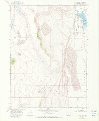
1968 Map of Guano Lake
USGS Topo · Published 1972About this map
Shirk Ranch anchors the northeastern corner of this high-desert basin, situated near the edge of the Hart Mountain Antelope Refuge. This 1968 field-checked map illustrates a landscape of seasonal water and livestock management, dominated by the expansive, often dry Guano Lake bed and the dramatic elevation change of the Shirk Rim. Small, eponymous bodies of water like Egg Lake, Corral Lake, and Round Lake dot the western plateau, while water control infrastructure is noted at the Spillway Elev 5200 and Dam near the Shirk Lake basin. The survey reveals the sparse connectivity of the region through a network of Jeep Trails and scattered resources like the Well and Little Reservoir, which supported the ranching operations typical of Lake County during the mid-20th century.
Find a feature on this map
23 named features on this map. Tap any name to fly to it.
Don’t see what you’re looking for? This feature index may not catch every label — zoom into the map to look around manually.
Map Details
Editions of this 1968 Guano Lake Map
2 editions found
Other maps of this area

1955 · Adel
USGS Topo · 1:250,000

1957 · Adel
USGS Topo · 1:250,000

1958 · Adel
USGS Topo · 1:250,000

1962 · Adel
USGS Topo · 1:250,000

1967 · Jacobs Reservoir
USGS Topo · 1:24,000

1967 · Alger Lake
USGS Topo · 1:24,000
1968 · Piute Reservoir
USGS Topo · 1:24,000

1968 · Guano Lake
USGS Topo · 1:24,000
1968 · Blizzard Gap
USGS Topo · 1:24,000
1968 · Mud Lake Reservoir
USGS Topo · 1:24,000