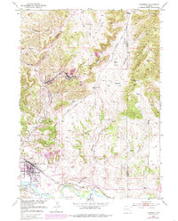
1950 Map of Guernsey
USGS Topo · Published 1985About this map
Iron ore mining and military activity define this mid-century landscape in Platte County. The intensive industrial operations at Sunrise and Hartville are evident through the Mine Dump and the Good Fortune Mine, while the town of Guernsey serves as a hub for both the Burlington and Colo and Wyo railroads. The southern portion of the map highlights the proximity of the State Military Reservation and Camp Guernsey, alongside local aviation at the Guernsey Landing Field. To the east, the Haystack Range provides a sharp contrast to the developed river valley. Historic transit remains visible through the marked path of the Oregon Trail near the North Platte River, providing a layer of pioneer history over the modern extraction economy. Scattered family sites like Frederick Ranch and Old Guernsey Ranch illustrate the rural ranching pattern that persists beyond the industrial centers.
Find a feature on this map
43 named features on this map. Tap any name to fly to it.
Don’t see what you’re looking for? This feature index may not catch every label — zoom into the map to look around manually.
Map Details
Editions of this 1950 Guernsey Map
4 editions found
Other maps of this area

1896 · Hartville
USGS Topo · 1:125,000

1901 · Hartville
USGS Topo · 1:125,000

1950 · Guernsey
USGS Topo · 1:24,000

1950 · Casebier Hill
USGS Topo · 1:24,000

1950 · Fort Laramie
USGS Topo · 1:24,000

1950 · Register Cliff
USGS Topo · 1:24,000

1950 · Haushar Ranch
USGS Topo · 1:24,000

1950 · Hell Gap
USGS Topo · 1:24,000

1950 · Guernsey Reservoir
USGS Topo · 1:24,000

1951 · Haushar Ranch
USGS Topo · 1:24,000