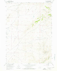
1955 Map of Guide Rock
USGS Topo · Published 1976About this map
Guide Rock stands as a prominent landmark within this 1955 survey of the Laramie Mountains, where the landscape is defined by a dense network of high-altitude drainages and ridge systems. To the south, the Sybille Game and Fish Experimental Unit occupies a significant portion of the terrain, reflecting the mid-century focus on wildlife management and conservation in Albany County. The drainage patterns of Bluegrass Creek and its branches, including West Bluegrass Creek and East Bluegrass Creek, illustrate the complex topography of Bluegrass Ridge. This map captures the region during the Missouri River Basin development era, documenting the precise locations of remote canyons like Halleck Canyon and the headwaters of School Creek and Johnson Creek.
Find a feature on this map
19 named features on this map. Tap any name to fly to it.
Don’t see what you’re looking for? This feature index may not catch every label — zoom into the map to look around manually.
Map Details
Editions of this 1955 Guide Rock Map
3 editions found
Other maps of this area

1954 · Cheyenne
USGS Topo · 1:250,000

1955 · Poe Mountain
USGS Topo · 1:24,000

1955 · Dodge Ranch
USGS Topo · 1:24,000

1955 · Bluegrass Wells
USGS Topo · 1:24,000

1955 · Sybille Springs
USGS Topo · 1:24,000

1955 · Moonshine Peak
USGS Topo · 1:24,000

1955 · Indian Guide
USGS Topo · 1:24,000

1955 · Guide Rock
USGS Topo · 1:24,000

1955 · Sheep Rock
USGS Topo · 1:24,000

1955 · Bull Camp Peak
USGS Topo · 1:24,000