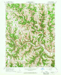
1966 Map of Guilford
USGS Topo · Published 1968About this map
Tanners Creek carves a deep path through the southeastern Indiana countryside, defining the orientation of the small settlements and ridgeline roads in this part of Dearborn County. The map captures the mid-century layout of historic Catholic parishes, such as St Johns Ch and St Josephs Ch, which anchored the rural communities of New Alsace and St Leon. The landscape is dominated by a series of prominent elevations including York Ridge, Sawdon Ridge, and Mt Pleasant Ridge, which forced many early transportation routes to follow the spine of the high ground. Local genealogy is well-documented through several family and church burial grounds, including the Huber Boggs Cem and Pelley Cem. The convergence of the West Fork and East Fork of Tanners Creek near Guilford highlights the geographic importance of this junction for local infrastructure and early development patterns in York and Miller townships.
Find a feature on this map
54 named features on this map. Tap any name to fly to it.
Don’t see what you’re looking for? This feature index may not catch every label — zoom into the map to look around manually.
Map Details
Editions of this 1966 Guilford Map
2 editions found
Other maps of this area

1915 · Lawrenceburg
USGS Topo · 1:48,000

1915 · Harrison
USGS Topo · 1:48,000

1928 · Lawrenceburg
USGS Topo · 1:62,500

1932 · Lawrenceburg
USGS Topo · 1:62,500

1943 · Aurora
USGS Topo · 1:24,000

1943 · Hooven
USGS Topo · 1:24,000

1943 · Guilford
USGS Topo · 1:24,000

1943 · Lawrenceburg
USGS Topo · 1:24,000

1953 · Aurora
USGS Topo · 1:24,000

1953 · Guilford
USGS Topo · 1:24,000