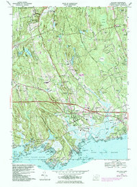
1968 Map of Guilford
USGS Topo · Published 1984About this map
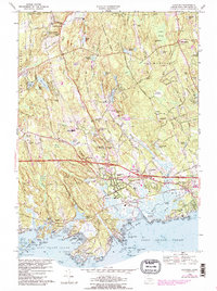
The Guilford shoreline and the heavily wooded interior of the Cockaponset State Forest characterize this New Haven County landscape during the late 1960s. The town's historical settlement pattern is clearly visible, concentrated around the Guilford Harbor and extending north through Nut Plains to North Guilford. Along the coast, the complex geography of Joshua Cove, Sachem Head, and Leetes Island is detailed with its numerous small islands like Hen Island and Cat Island. Transport infrastructure is prominent, featuring the Amtrak rail line running parallel to the coast and the Connecticut Turnpike cutting through the center of the quadrangle. Local civic life is represented by several schools, including the Guilford High Sch and Jr High Sch, and numerous burial grounds such as Alderbrook Cem and the West Side Cem. In the north, the Our Lady of Grace Monastery sits near Kelsey Pond, marking a quiet institutional presence in the uplands.
Find a feature on this map
122 named features on this map. Tap any name to fly to it.
Don’t see what you’re looking for? This feature index may not catch every label — zoom into the map to look around manually.
Map Details
Editions of this 1968 Guilford Map
5 editions found
Other maps of this area

1892 · New Haven
USGS Topo · 1:62,500

1893 · Guilford
USGS Topo · 1:62,500

1921 · New Haven
USGS Topo · 1:62,500

1943 · Durham
USGS Topo · 1:25,000

1947 · Hartford
USGS Topo · 1:250,000

1948 · Hartford
USGS Topo · 1:250,000

1951 · Clinton
USGS Topo · 1:31,680

1952 · Haddam
USGS Topo · 1:31,680

1953 · Durham
USGS Topo · 1:31,680

1954 · Guilford
USGS Topo · 1:31,680