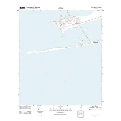
2012 Map of Gulf Breeze
USGS Topo · Published 2012About this map
Santa Rosa Island stretches across this coastal survey, separating the protected waters of Santa Rosa Sound from the open Gulf of Mexico. The peninsula of Villa Sabine serves as a primary residential and recreational hub, connected to the mainland by the Bob Sikes Bridge and bordered by the calm inlets of Little Sabine Bay and Sabine Inlet. The geography here is defined by numerous points and coves, such as Deer Point, Grassy Point, and Old Navy Cove, reflecting a landscape deeply tied to the maritime activity of Pensacola Bay. This 2012 map documents the modern street layout and coastal developments of Pensacola Beach and its surrounding communities, including Forest Lawn of Santa Rosa and Serenity Gardens, during a period of established beach-front infrastructure and permanent residential growth along the Gulf coast.
Find a feature on this map
52 named features on this map. Tap any name to fly to it.
Don’t see what you’re looking for? This feature index may not catch every label — zoom into the map to look around manually.
Map Details
Editions of this 2012 Gulf Breeze Map
This is the sole edition of this map. No revisions or reprints were ever made.
Other maps of this area

1921 · Pensacola
USGS Topo · 1:62,500

1921 · Fort Barrancas
USGS Topo · 1:62,500

1941 · Fort Barrancas
USGS Topo · 1:62,500

1941 · Pensacola
USGS Topo · 1:62,500

1942 · Pensacola
USGS Topo · 1:62,500

1943 · Fort Barrancas
USGS Topo · 1:62,500

1944 · West Pensacola
USGS Topo · 1:25,000
1944 · Oriole Beach
USGS Topo · 1:25,000

1944 · Gulf Breeze
USGS Topo · 1:25,000
1944 · Fort Barrancas
USGS Topo · 1:25,000