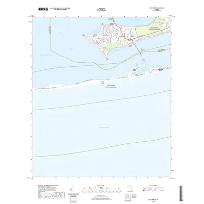
2018 Map of Gulf Breeze
USGS Topo · Published 2018About this map
Gulf Breeze sits prominently on the peninsula between Pensacola Bay and the Santa Rosa Sound, serving as a central hub for the barrier island communities and maritime transit. This 2018 coastal study captures the sophisticated network of bridges and waterways that define the region, notably the Pensacola Bay Bridge connecting the mainland and the Bob Sikes Bridge leading to Santa Rosa Island. The geography is shaped by numerous coastal indentations such as Old Navy Cove and English Navy Cove, while the southern reaches are dominated by the protected lands of the Gulf Islands National Seashore.
Find a feature on this map
34 named features on this map. Tap any name to fly to it.
Don’t see what you’re looking for? This feature index may not catch every label — zoom into the map to look around manually.
Map Details
Editions of this 2018 Gulf Breeze Map
This is the sole edition of this map. No revisions or reprints were ever made.
Other maps of this area

1921 · Pensacola
USGS Topo · 1:62,500

1921 · Fort Barrancas
USGS Topo · 1:62,500

1941 · Fort Barrancas
USGS Topo · 1:62,500

1941 · Pensacola
USGS Topo · 1:62,500

1942 · Pensacola
USGS Topo · 1:62,500

1943 · Fort Barrancas
USGS Topo · 1:62,500

1944 · West Pensacola
USGS Topo · 1:25,000
1944 · Oriole Beach
USGS Topo · 1:25,000

1944 · Gulf Breeze
USGS Topo · 1:25,000
1944 · Fort Barrancas
USGS Topo · 1:25,000