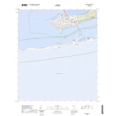
2024 Map of Gulf Breeze
USGS Topo · Published 2024About this map
Gulf Breeze and its surrounding coastal communities are shown at the height of their modern development on the narrow peninsula and barrier islands separating Pensacola Bay from the Gulf of Mexico. The residential character of the area is defined by a dense network of streets like Shoreline Drive and Navy Cove Boulevard which cluster near landmarks like Duncan Cem and the Gulf Breeze United Methodist Church. To the south, across the Santa Rosa Sound, the map details the transition to the protected environment of the Gulf Islands National Seashore and the community of Pensacola Beach. The geography here is a series of coves and inlets, including English Navy Cove and Little Sabine Bay, highlighting the maritime orientation of Villa Sabine. This coastal strip, bound by the Intracoastal Waterway, reflects a landscape shared between permanent residential life and national conservation efforts.
Find a feature on this map
74 named features on this map. Tap any name to fly to it.
Don’t see what you’re looking for? This feature index may not catch every label — zoom into the map to look around manually.
Map Details
Editions of this 2024 Gulf Breeze Map
This is the sole edition of this map. No revisions or reprints were ever made.
Other maps of this area

1921 · Pensacola
USGS Topo · 1:62,500

1921 · Fort Barrancas
USGS Topo · 1:62,500

1941 · Fort Barrancas
USGS Topo · 1:62,500

1941 · Pensacola
USGS Topo · 1:62,500

1942 · Pensacola
USGS Topo · 1:62,500

1943 · Fort Barrancas
USGS Topo · 1:62,500

1944 · West Pensacola
USGS Topo · 1:25,000
1944 · Oriole Beach
USGS Topo · 1:25,000

1944 · Gulf Breeze
USGS Topo · 1:25,000
1944 · Fort Barrancas
USGS Topo · 1:25,000