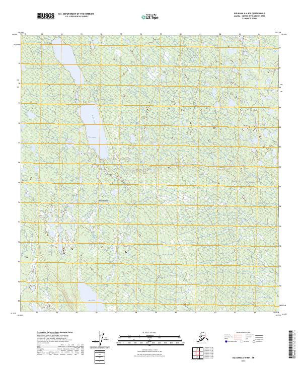
2023 Map of Gulkana A-4 NW
USGS Topo · Published 2023About this map
The settlement of Glennallen serves as a focal point within this Interior Alaska landscape, situated where the wilderness meets localized development. This modern topographic study reveals a terrain defined by subtle hydrology and low-lying wetlands, characterized by the winding path of Moose Creek and several distinct water bodies including Twin Lakes, Round Lake, and Mud Lake. The map illustrates the structured division of the land through township and range boundaries such as t5n r4w and t4n r3w, reflecting the systematic surveying of the Copper River Census Area. For those studying recent land use or environmental change, the relationship between the established townsite and the surrounding marshy corridors provides essential context on how the community interacts with the local watershed.
Find a feature on this map
9 named features on this map. Tap any name to fly to it.
Don’t see what you’re looking for? This feature index may not catch every label — zoom into the map to look around manually.
Map Details
Editions of this 2023 Gulkana A-4 NW Map
This is the sole edition of this map. No revisions or reprints were ever made.
Other maps of this area

1949 · Gulkana A-5
USGS Topo · 1:63,360

1951 · Gulkana
USGS Topo · 1:250,000

1951 · Gulkana B-5
USGS Topo · 1:63,360

1951 · Gulkana A-4
USGS Topo · 1:63,360

1951 · Gulkana B-4
USGS Topo · 1:63,360

1952 · Gulkana A-5
USGS Topo · 1:63,360

1952 · Gulkana A-4
USGS Topo · 1:63,360
1952 · Gulkana B-4
USGS Topo · 1:63,360
1952 · Gulkana B-5
USGS Topo · 1:63,360

1959 · Gulkana
USGS Topo · 1:250,000