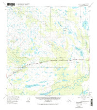
1949 Map of Gulkana A-5
USGS Topo · Published 1964About this map
The Glenn Highway serves as the primary artery through this interior Alaskan landscape, connecting isolated settlements and transit points in the late 1940s. Travelers and residents relied on localized landmarks such as Trappers Den, Lakeview, and the Atlasta House for navigation and shelter along this rugged corridor. The map reveals the early infrastructure of the region, including a Landing Strip near the small community of Tazlina, which sits at the junction of critical waterways and the developing road system.
Find a feature on this map
32 named features on this map. Tap any name to fly to it.
Don’t see what you’re looking for? This feature index may not catch every label — zoom into the map to look around manually.
Map Details
Editions of this 1949 Gulkana A-5 Map
3 editions found
Other maps of this area

1949 · Gulkana A-5
USGS Topo · 1:63,360

1949 · Gulkana A-6
USGS Topo · 1:63,360

1949 · Valdez D-6
USGS Topo · 1:63,360

1949 · Valdez D-7
USGS Topo · 1:63,360

1950 · Gulkana B-6
USGS Topo · 1:63,360

1951 · Gulkana
USGS Topo · 1:250,000

1951 · Valdez D-6
USGS Topo · 1:63,360

1951 · Valdez D-7
USGS Topo · 1:63,360

1951 · Gulkana B-5
USGS Topo · 1:63,360

1951 · Gulkana A-4
USGS Topo · 1:63,360