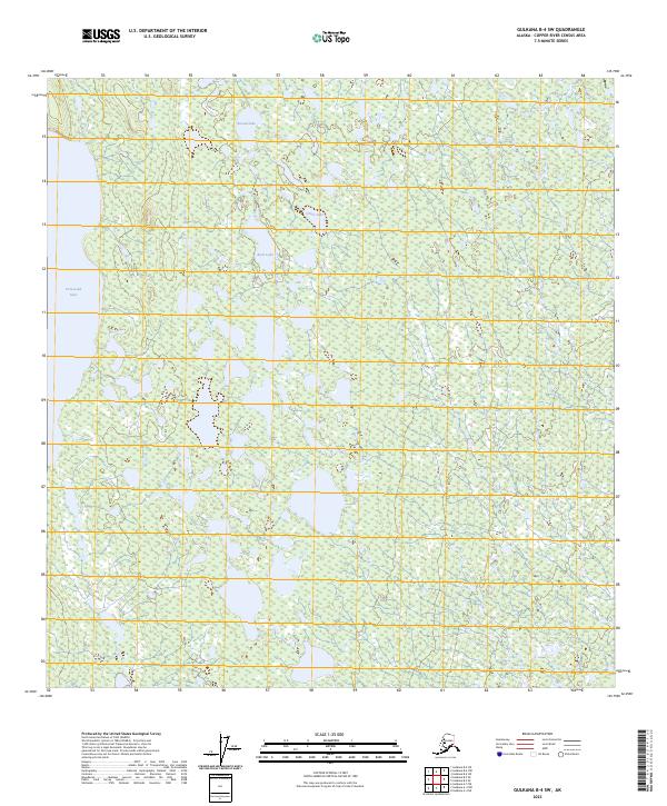
2023 Map of Gulkana B-4 SW
USGS Topo · Published 2023About this map
Crosswind Lake dominates the western edge of this 2023 survey in the Copper River Census Area, serving as the primary landmark in a landscape defined by an intricate network of wetlands and small water bodies. The terrain is characterized by a high density of small, unnamed ponds and marshy areas typical of this subarctic interior region. Central to the sheet, a chain of named features including Round Lake, Grass Lake, and Rock Lake provides distinct points of reference for navigation and land use within the township boundaries of t7n r4w and t6n r4w. This map illustrates a largely undisturbed hydrological system where small lakes are interconnected by a complex drainage pattern, reflecting the natural state of the Alaskan wilderness north of the Copper River.
Find a feature on this map
8 named features on this map. Tap any name to fly to it.
Don’t see what you’re looking for? This feature index may not catch every label — zoom into the map to look around manually.
Map Details
Editions of this 2023 Gulkana B-4 SW Map
This is the sole edition of this map. No revisions or reprints were ever made.
Other maps of this area

1949 · Gulkana A-5
USGS Topo · 1:63,360

1951 · Gulkana
USGS Topo · 1:250,000

1951 · Gulkana B-5
USGS Topo · 1:63,360

1951 · Gulkana A-4
USGS Topo · 1:63,360

1951 · Gulkana B-4
USGS Topo · 1:63,360

1952 · Gulkana A-5
USGS Topo · 1:63,360

1952 · Gulkana A-4
USGS Topo · 1:63,360
1952 · Gulkana B-4
USGS Topo · 1:63,360
1952 · Gulkana B-5
USGS Topo · 1:63,360

1959 · Gulkana
USGS Topo · 1:250,000