
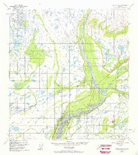
1949 Map of Gulkana C-2
USGS Topo · Published 1963About this map
Chistochina River and the braided channels of the Copper River dominate this Alaskan landscape, captured during a period of transition for northern travel. The settlement at Chistochina sits at a strategic junction where the river meets the Glenn Highway, which served as a critical corridor connecting the interior. The presence of a Landing Strip and a local Gravel Pit indicates the infrastructure required to maintain this remote outpost and its roadway during the mid-20th century.
Find a feature on this map
13 named features on this map. Tap any name to fly to it.
Don’t see what you’re looking for? This feature index may not catch every label — zoom into the map to look around manually.
Map Details
Editions of this 1949 Gulkana C-2 Map
2 editions found
Other maps of this area

1949 · Gulkana D-3
USGS Topo · 1:63,360

1949 · Gulkana B-2
USGS Topo · 1:63,360

1949 · Gulkana C-1
USGS Topo · 1:63,360

1950 · Gulkana B-3
USGS Topo · 1:63,360

1950 · Gulkana C-3
USGS Topo · 1:63,360

1951 · Gulkana
USGS Topo · 1:250,000

1952 · Gulkana D-3
USGS Topo · 1:63,360

1952 · Gulkana B-3
USGS Topo · 1:63,360

1952 · Gulkana B-2
USGS Topo · 1:63,360

1952 · Gulkana C-2
USGS Topo · 1:63,360