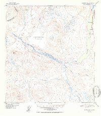
1952 Map of Gulkana D-4
USGS Topo · Published 1952About this map
Gulkana River and the northern shores of Paxson Lake define the eastern corridor of this 1952 topographic study. This era captures the early roadside infrastructure along the Richardson Highway, where Sportsman Lodge and Hufmans served travelers near Mile 180. The landscape transitions from the river valley into the high elevations of Flat Top Mountain, surrounded by a network of tractor trails that push westward toward Hungry Hollow. Unique to this specific document is a large central void labeled No compilation available for this area (obscured by clouds), a literal artifact of the aerial photography process used by the Geological Survey during the 1949 flyover. Beyond the highway, the map traces the Middle Fork and Twentymile Creek, showing isolated cabins and paths that represent the early footprints of habitation in this subarctic interior.
Find a feature on this map
20 named features on this map. Tap any name to fly to it.
Don’t see what you’re looking for? This feature index may not catch every label — zoom into the map to look around manually.
Map Details
Editions of this 1952 Gulkana D-4 Map
2 editions found

Other maps of this area

1949 · Mount Hayes A-4
USGS Topo · 1:63,360

1949 · Gulkana D-3
USGS Topo · 1:63,360

1949 · Mount Hayes A-5
USGS Topo · 1:63,360

1950 · Mount Hayes
USGS Topo · 1:250,000

1950 · Gulkana D-4
USGS Topo · 1:63,360

1950 · Mount Hayes A-3
USGS Topo · 1:63,360

1950 · Gulkana C-3
USGS Topo · 1:63,360

1950 · Gulkana C-4
USGS Topo · 1:63,360

1951 · Gulkana
USGS Topo · 1:250,000

1951 · Mount Hayes
USGS Topo · 1:250,000