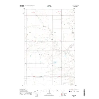
2020 Map of Gunsight
USGS Topo · Published 2020About this map
Gunsight sits in a landscape defined by the winding course of Cut Bank Creek and a network of named coulees in eastern Glacier County. The terrain is shaped by dramatic drainage features such as South Fork Little Rock Coulee, Little Rock Coulee, and Big Rock Coulee, which cut through the high plains toward the creek bed. Local water management and irrigation are evident through the Q Lateral canal, which serves the agricultural lands south of the primary creek. A series of small lakes, including Conway Lake, Hope Lake, and Allison Lake, dot the southern half of the quadrangle, connected by a grid of rural routes like Pendergrass Rd and Henderson Rd. The map illustrates a contemporary pattern of land use where large-scale ranching and farming infrastructure intersect with the natural hydrology of the Montana plains.
Find a feature on this map
24 named features on this map. Tap any name to fly to it.
Don’t see what you’re looking for? This feature index may not catch every label — zoom into the map to look around manually.
Map Details
Editions of this 2020 Gunsight Map
This is the sole edition of this map. No revisions or reprints were ever made.
Other maps of this area

1907 · Blackfoot Res.
USGS Topo · 1:48,000

1909 · Cut Bank
USGS Topo · 1:125,000

1911 · Blackfoot
USGS Topo · 1:125,000

1912 · Cut Bank
USGS Topo · 1:125,000

1960 · Cut Bank
USGS Topo · 1:250,000

1963 · Cut Bank
USGS Topo · 1:250,000

1964 · Cut Bank
USGS Topo · 1:250,000
1966 · Cut Bank
USGS Topo · 1:24,000
1966 · Cut Bank SE
USGS Topo · 1:24,000
1966 · Squaw Buttes
USGS Topo · 1:24,000