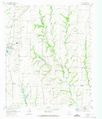
1961 Map of Gunter
USGS Topo · Published 1975About this map
Gunter serves as the primary hub in this corner of North Texas, situated along the St Louis San Francisco And Texas railroad line. The landscape is defined by the headwaters of the East Fork Trinity River, which meanders through a terrain marked by numerous family and community burial grounds, including Whitaker Cem, Elliott Cem, and Mc Donald Cem. These small cemeteries are often found near local tributaries like Squirrel Creek and Stanley Creek, reflecting a settlement pattern tied closely to the area's drainage and agricultural potential.
Find a feature on this map
28 named features on this map. Tap any name to fly to it.
Don’t see what you’re looking for? This feature index may not catch every label — zoom into the map to look around manually.
Map Details
Editions of this 1961 Gunter Map
2 editions found
Other maps of this area

1901 · Denison
USGS Topo · 1:125,000

1954 · Sherman
USGS Topo · 1:250,000

1958 · Dorchester
USGS Topo · 1:24,000

1958 · Whitesboro
USGS Topo · 1:62,500

1958 · Sherman
USGS Topo · 1:250,000

1958 · Sherman
USGS Topo · 1:62,500

1958 · Howe
USGS Topo · 1:24,000

1960 · Celina
USGS Topo · 1:24,000

1961 · Gunter
USGS Topo · 1:24,000

1961 · Van Alstyne
USGS Topo · 1:24,000