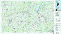
1984 Map of Guntersville
USGS Topo · Published 1985About this map
The Tennessee River corridor dominates this mid-1980s landscape, winding through a complex topography of ridges and valleys defined by Brindley Mountain and Sand Mountain. This 1:100,000-scale study captures the sprawling waters of Guntersville Lake and Wheeler Lake, along with the conservation lands of the Wheeler National Wildlife Refuge. The map illustrates a mature regional infrastructure, where the Louisville and Nashville RR and Southern Ry intersect with modern thoroughfares like I-65.
Find a feature on this map
83 named features on this map. Tap any name to fly to it.
Don’t see what you’re looking for? This feature index may not catch every label — zoom into the map to look around manually.
Map Details
Editions of this 1984 Guntersville Map
2 editions found
Other maps of this area

1885 · Gadsden
USGS Topo · 1:125,000

1886 · Stevenson
USGS Topo · 1:125,000

1888 · Cullman
USGS Topo · 1:125,000

1888 · Gadsden
USGS Topo · 1:125,000

1888 · Scottsboro
USGS Topo · 1:125,000

1888 · Huntsville
USGS Topo · 1:125,000

1889 · Springville
USGS Topo · 1:125,000

1889 · Birmingham
USGS Topo · 1:125,000

1892 · Cullman
USGS Topo · 1:125,000

1892 · Birmingham
USGS Topo · 1:125,000