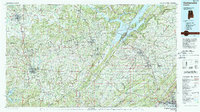
1984 Map of Guntersville
USGS Topo · Published 1988About this map
The Tennessee Valley Divide cuts through this northeast Alabama landscape, separating the waters flowing toward Guntersville Lake and the Tennessee River from those heading south into the Black Warrior basin. The topography is dominated by the massive presence of Brindley Mountain and Sand Mountain, which create a series of parallel valleys such as Wills Valley and Big Spring Valley. Regional hubs like Cullman, Albertville, and Guntersville anchor the map, showing the established 1980s road and rail infrastructure, including the Seaboard System and Louisville & Nashville lines.
Find a feature on this map
226 named features on this map. Tap any name to fly to it.
Don’t see what you’re looking for? This feature index may not catch every label — zoom into the map to look around manually.
Map Details
Editions of this 1984 Guntersville Map
2 editions found
Other maps of this area

1885 · Gadsden
USGS Topo · 1:125,000

1886 · Stevenson
USGS Topo · 1:125,000

1888 · Cullman
USGS Topo · 1:125,000

1888 · Gadsden
USGS Topo · 1:125,000

1888 · Scottsboro
USGS Topo · 1:125,000

1888 · Huntsville
USGS Topo · 1:125,000

1889 · Springville
USGS Topo · 1:125,000

1889 · Birmingham
USGS Topo · 1:125,000

1892 · Cullman
USGS Topo · 1:125,000

1892 · Birmingham
USGS Topo · 1:125,000