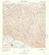
1952 Map of Gurabo
USGS Topo · Published 1953About this map
The Río Grande de Loíza and Río Gurabo define the low-lying agricultural corridors of this mid-century survey, where the town of Gurabo sits at the junction of critical regional routes. The landscape transitions from the river valleys into the steep ridges of Cuchilla de Hato Nuevo and Cerro Gordo, illustrating the traditional settlement patterns of the era. Significant communal infrastructure is mapped throughout the barrios, including the Cementerio Rural de Gurabo and a network of rural schools like the Escuela Segunda Unidad de Cacao and Escuela Abraham Lincoln. A U.S. Military Reservation occupies land in the southwest, while the intricate municipal boundaries between Carolina, Trujillo Alto, and Gurabo trace the high crests of the Quebrada Grande and Quebrada Negrito watersheds.
Find a feature on this map
69 named features on this map. Tap any name to fly to it.
Don’t see what you’re looking for? This feature index may not catch every label — zoom into the map to look around manually.
Map Details
Editions of this 1952 Gurabo Map
2 editions found
Other maps of this area

1940 · Carolina
USGS Topo · 1:30,000

1941 · San Juan
USGS Topo · 1:30,000

1941 · Rio Grande
USGS Topo · 1:30,000

1941 · Carolina
USGS Topo · 1:30,000

1945 · El Yunque
USGS Topo · 1:30,000

1946 · El Yunque
USGS Topo · 1:30,000

1946 · Aguas Buenas
USGS Topo · 1:30,000

1946 · Humacao
USGS Topo · 1:30,000

1946 · Gurabo
USGS Topo · 1:30,000

1946 · Juncos
USGS Topo · 1:30,000
Featured Places
- Gurabo
- Mariana, Carolina
- Sector Goyo Márquez, Gurabo
- La Marina, Canóvanas
- Mansiones del Tesoro, Canóvanas