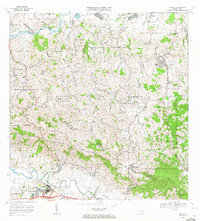
1969 Map of Gurabo
USGS Topo · Published 1972About this map
The Río Grande de Loiza and the Río Gurabo define the low-lying basins of this landscape, where the town of Gurabo sits at the junction of river valleys and rising mountain slopes. This 1969 field-checked survey captures the area during a period of transition, showing the Via del Ferrocarril and Via Antigua as markers of earlier transport corridors. Educational and institutional growth is evident through the Universidad de Puerto Rico Estación Experimental Agrícola and the Academia de la Policia.
Find a feature on this map
83 named features on this map. Tap any name to fly to it.
Don’t see what you’re looking for? This feature index may not catch every label — zoom into the map to look around manually.
Map Details
Editions of this 1969 Gurabo Map
2 editions found
Other maps of this area

1940 · Carolina
USGS Topo · 1:30,000

1941 · San Juan
USGS Topo · 1:30,000

1941 · Rio Grande
USGS Topo · 1:30,000

1941 · Carolina
USGS Topo · 1:30,000

1945 · El Yunque
USGS Topo · 1:30,000

1946 · El Yunque
USGS Topo · 1:30,000

1946 · Aguas Buenas
USGS Topo · 1:30,000

1946 · Humacao
USGS Topo · 1:30,000

1946 · Gurabo
USGS Topo · 1:30,000

1946 · Juncos
USGS Topo · 1:30,000
Featured Places
- Gurabo
- La Marina, Canóvanas
- Sector Los Canales, Carolina
- Sector El Counte, Carolina
- Colinas de Cacao, Carolina