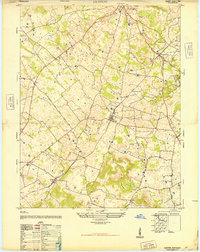
1948 Map of Guston
USGS Topo · Published 1948About this map
The agrarian landscape of Meade County is centered on the railway village of Ekron and the neighboring community of Guston, where the Illinois Central railroad provides the primary industrial artery for local trade. This 1947 survey, compiled from aerial photography, reveals a network of rural settlements connected by a web of local roads such as Midway Road and Stringtown Road. The distribution of family and community landmarks, including the Meade County Farm and Smith School, suggests a well-established social fabric in the years following World War II. Local genealogy is anchored by historic religious sites like New Highland Church and the Weldon Church and Cemetery near Brandenburg Station. The topography is characterized by numerous small depressions and ponds south of Frostown Road, while the northeastern corner is defined by the incision of Doe Run.
Find a feature on this map
28 named features on this map. Tap any name to fly to it.
Don’t see what you’re looking for? This feature index may not catch every label — zoom into the map to look around manually.
Map Details
Editions of this 1948 Guston Map
This is the sole edition of this map. No revisions or reprints were ever made.
Other maps of this area

1928 · Hardinsburg
USGS Topo · 1:48,000

1931 · Hardinsburg
USGS Topo · 1:62,500

1931 · Corydon
USGS Topo · 1:62,500

1941 · Ekron
USGS Topo · 1:62,500

1946 · Rock Haven
USGS Topo · 1:24,000

1947 · Irvington
USGS Topo · 1:24,000

1947 · Garfield
USGS Topo · 1:24,000

1947 · Mauckport
USGS Topo · 1:24,000

1947 · Hardinsburg
USGS Topo · 1:62,500

1947 · Ekron
USGS Topo · 1:62,500