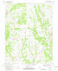
1969 Map of Guthrie
USGS Topo · Published 1982About this map
Guthrie and Carrington anchor this mid-century look at central Missouri, where the landscape transitions from the open expanses of Round Prairie to the dissected drainages of the Middle River. This 1969 survey, revised in 1980, reveals a community structure built around local institutions, including the Carrington Sch and religious landmarks like Millers Creek Ch. The geography is defined by a dense network of family and community burial grounds, such as White Cloud Cem and Boydsville Cem, providing essential data for those tracing local lineages.
Find a feature on this map
27 named features on this map. Tap any name to fly to it.
Don’t see what you’re looking for? This feature index may not catch every label — zoom into the map to look around manually.
Map Details
Editions of this 1969 Guthrie Map
2 editions found
Other maps of this area

1886 · Jefferson City
USGS Topo · 1:125,000

1890 · Fulton
USGS Topo · 1:125,000

1894 · Jefferson City
USGS Topo · 1:125,000

1928 · Fulton
USGS Topo · 1:62,500

1931 · Fulton
USGS Topo · 1:62,500

1939 · Jefferson City
USGS Topo · 1:62,500

1942 · Jefferson City
USGS Topo · 1:62,500

1944 · Millersburg
USGS Topo · 1:62,500

1945 · Mokane
USGS Topo · 1:62,500

1946 · Millersburg
USGS Topo · 1:62,500