
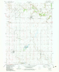
1982 Map of Guthrie Center East
USGS Topo · Published 1983About this map
Guthrie Center serves as the focal point of this Guthrie County landscape, established where the Mid Raccoon River and Brushy Creek systems converge. The map reflects a rural economy in transition during the early 1980s, where an Old Railroad Grade near Monteith marks the path of former rail commerce, while the development of Lake Panorama to the northeast suggests a shift toward recreation.
Find a feature on this map
31 named features on this map. Tap any name to fly to it.
Don’t see what you’re looking for? This feature index may not catch every label — zoom into the map to look around manually.
Map Details
Editions of this 1982 Guthrie Center East Map
This is the sole edition of this map. No revisions or reprints were ever made.
Other maps of this area

1952 · Panora
USGS Topo · 1:62,500

1954 · Bagley
USGS Topo · 1:62,500

1954 · Omaha
USGS Topo · 1:250,000

1957 · Omaha
USGS Topo · 1:250,000

1958 · Omaha
USGS Topo · 1:250,000

1971 · Bayard
USGS Topo · 1:24,000

1971 · Casey
USGS Topo · 1:24,000

1971 · Guthrie Center West
USGS Topo · 1:24,000

1982 · Panora
USGS Topo · 1:24,000
1982 · Yale
USGS Topo · 1:24,000