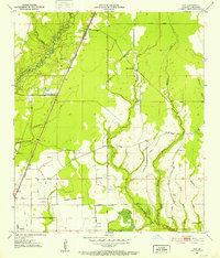
1951 Map of Guy
USGS Topo · Published 1952About this map
The Missouri Pacific railroad corridor defines the development of this Allen Parish landscape, cutting a straight line through the timber and wetlands north of Oberlin. Small settlements like Guy and Foley dot the tracks, serving as anchors for local families whose history is preserved in small burial grounds such as Reed Cem and Durose Cem. To the east, the terrain is shaped by the winding paths of Castor Creek and Mitchell Creek, where the McGee Mission and St Johns Chapel represent the rural social centers of the mid-century era.
Find a feature on this map
26 named features on this map. Tap any name to fly to it.
Don’t see what you’re looking for? This feature index may not catch every label — zoom into the map to look around manually.
Map Details
Editions of this 1951 Guy Map
This is the sole edition of this map. No revisions or reprints were ever made.
Other maps of this area

1935 · Beaver
USGS Topo · 1:31,680

1935 · Oakdale
USGS Topo · 1:31,680

1942 · Oakdale
USGS Topo · 1:62,500

1947 · Fruge Lake
USGS Topo · 1:31,680

1947 · Foley
USGS Topo · 1:31,680

1947 · Oberlin
USGS Topo · 1:31,680

1947 · Pine Chapel
USGS Topo · 1:31,680

1947 · Bond
USGS Topo · 1:31,680

1947 · Elizabeth
USGS Topo · 1:31,680

1948 · Elizabeth
USGS Topo · 1:24,000