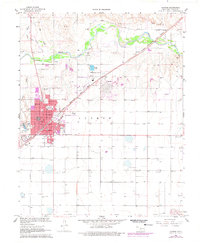
1968 Map of Guymon
USGS Topo · Published 1977About this map
Guymon serves as the focal point of this Panhandle landscape, where the Chicago Rock Island and Pacific railroad cuts a diagonal line through the plains toward the Beaver River. The settlement pattern of the late 1960s is clearly visible, with civic hubs like City Hall, the Post Office, and a Hospital anchored in the town center. Educational and community institutions are well-distributed, including Long School, Academy School, and Carrier School, alongside local recreation spots like the Golf Course and Drive-in Theater. Beyond the urban boundary, the geography is defined by water management and natural drainage, from the Sewage Disposal Ponds to the meandering Goff Creek and Little Goff Creek. For genealogists and local historians, the map preserves the locations of Elmhurst Cemetery and Carter Cemetery, while the presence of a Landing Strip, Feed Lot, and numerous gas wells reflects the region's agricultural and energy-driven economy.
Find a feature on this map
30 named features on this map. Tap any name to fly to it.
Don’t see what you’re looking for? This feature index may not catch every label — zoom into the map to look around manually.
Map Details
Editions of this 1968 Guymon Map
2 editions found
Other maps of this area

1954 · Perryton
USGS Topo · 1:250,000

1958 · Perryton
USGS Topo · 1:250,000

1967 · Straight SW
USGS Topo · 1:24,000

1967 · Optima
USGS Topo · 1:24,000

1968 · Guymon
USGS Topo · 1:24,000

1968 · Guymon SW
USGS Topo · 1:24,000

1968 · Guymon NE
USGS Topo · 1:24,000

1968 · Guymon SE
USGS Topo · 1:24,000

1973 · Goodwell SE
USGS Topo · 1:24,000

1973 · Goodwell NE
USGS Topo · 1:24,000