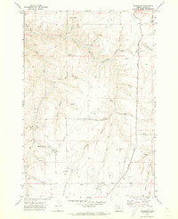
1970 Map of Gwendolen
USGS Topo · Published 1973About this map
Gwendolen stands as a rail-dependent settlement along the Union Pacific line in this 1970 survey of Gilliam County. The landscape is defined by the high plateaus of Wester Butte and Bulls Eye Butte, cut through by deep drainage systems like Johnson Canyon and Hay Fork Hollow. Agricultural infrastructure is prominent, including a Grain Elevator at the tracks and the Wells Pumping Station near City Farm. The presence of the Johnson Landing Strip and a complex network of Roads and Jeep Trails suggests a remote ranching economy reliant on these lifelines. Numerous mapped springs and cisterns reveal the critical importance of water management in this high-desert environment, where the Dry Fork Hay Creek and other seasonal washes carve the terrain.
Find a feature on this map
26 named features on this map. Tap any name to fly to it.
Don’t see what you’re looking for? This feature index may not catch every label — zoom into the map to look around manually.
Map Details
Editions of this 1970 Gwendolen Map
This is the sole edition of this map. No revisions or reprints were ever made.
Other maps of this area

1916 · Condon
USGS Topo · 1:125,000

1953 · The Dalles
USGS Topo · 1:250,000

1956 · The Dalles
USGS Topo · 1:250,000

1957 · The Dalles
USGS Topo · 1:250,000

1970 · Devils Backbone
USGS Topo · 1:24,000
1970 · Wolf Hollow Falls
USGS Topo · 1:24,000

1970 · Igo Butte
USGS Topo · 1:24,000
1970 · Schott Canyon
USGS Topo · 1:24,000

1970 · Condon
USGS Topo · 1:24,000
1970 · Matney Flat
USGS Topo · 1:24,000