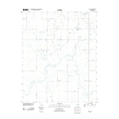
2012 Map of Gypsy
USGS Topo · Published 2012About this map
Deep Fork meanders through the heart of this Creek County landscape, carving a complex riparian corridor between the small communities of Gypsy and Iron Post. The area is defined by a rural grid of section roads, including N3670 Rd and W 301st St S, which navigate a terrain drained by numerous tributaries like Salt Cr, Bachelor Cr, and Wolfe Cr. A notable man-made feature, the Salt Camp Cr Site 4 Reservoir, sits in the northwest quadrant, highlighting the region's water management and land use.
Find a feature on this map
41 named features on this map. Tap any name to fly to it.
Don’t see what you’re looking for? This feature index may not catch every label — zoom into the map to look around manually.
Map Details
Editions of this 2012 Gypsy Map
This is the sole edition of this map. No revisions or reprints were ever made.
Other maps of this area

1901 · Nuyaka
USGS Topo · 1:125,000

1916 · Bristow
USGS Topo · 1:62,500

1929 · Stroud
USGS Topo · 1:62,500

1931 · Drumright
USGS Topo · 1:62,500

1932 · Stroud
USGS Topo · 1:62,500

1954 · Oklahoma City
USGS Topo · 1:250,000

1957 · Oklahoma City
USGS Topo · 1:250,000

1963 · Oklahoma City
USGS Topo · 1:250,000
1973 · Slick
USGS Topo · 1:24,000
1973 · Newby
USGS Topo · 1:24,000