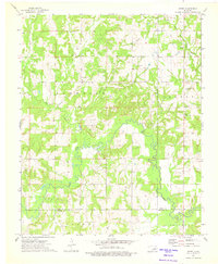
1973 Map of Gypsy
USGS Topo · Published 1975About this map
The Oil Field landscape of the Creek and Okfuskee county line is defined by a dense network of extraction infrastructure and riparian woodlands in this early 1970s survey. Centered on the small settlement of Gypsy, the area is punctuated by traditional community landmarks including Gypsy Ch and the Bucktrot Cem. The terrain is deeply carved by the meandering Deep Fork river and its tributaries like Salt Creek and Bachelor Creek, creating a complex topography of ridges and bottoms. To the east, the Newby area features additional religious sites such as the Greater Mt Hermon Ch and the Church of God, alongside industrial elements like various Quarries and a prominent Lookout Tower. This map documents a rural Oklahoma interior where the petroleum industry and subsistence landmarks like small country churches remained the primary drivers of the local geography.
Find a feature on this map
20 named features on this map. Tap any name to fly to it.
Don’t see what you’re looking for? This feature index may not catch every label — zoom into the map to look around manually.
Map Details
Editions of this 1973 Gypsy Map
This is the sole edition of this map. No revisions or reprints were ever made.
Other maps of this area

1901 · Nuyaka
USGS Topo · 1:125,000

1916 · Bristow
USGS Topo · 1:62,500

1929 · Stroud
USGS Topo · 1:62,500

1931 · Drumright
USGS Topo · 1:62,500

1932 · Stroud
USGS Topo · 1:62,500

1954 · Oklahoma City
USGS Topo · 1:250,000

1957 · Oklahoma City
USGS Topo · 1:250,000

1963 · Oklahoma City
USGS Topo · 1:250,000
1973 · Slick
USGS Topo · 1:24,000
1973 · Newby
USGS Topo · 1:24,000