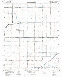
1954 Map of Hacienda Ranch NE
USGS Topo · Published 1985About this map
The vast Tulare Lake Bed dominates this portion of the San Joaquin Valley, showing a landscape defined by industrial agriculture and resource extraction. The area is heavily engineered with a network of canals and levees, including the Homeland Canal and Alpaugh Irrigation District Canal, which managed water flow across the low-lying terrain. Settlement is sparse and primarily functional, centered around the Farm Labor Camp and the Crockett and Gambogy Ranch, the latter of which features its own Landing Field and Oil Tanks. To the south, the Trico Gas Field and scattered Gas Wells indicate the region's energy production history. The presence of numerous secondary roads like Salem Ave and Seattle Ave following strict section lines reveals the systematic reclamation and partition of the former lake basin for farming.
Find a feature on this map
29 named features on this map. Tap any name to fly to it.
Don’t see what you’re looking for? This feature index may not catch every label — zoom into the map to look around manually.
Map Details
Editions of this 1954 Hacienda Ranch NE Map
3 editions found
Other maps of this area

1914 · Lost Hills
USGS Topo · 1:125,000

1927 · Lake View School
USGS Topo · 1:31,680

1928 · Corcoran
USGS Topo · 1:31,680

1929 · Alpaugh
USGS Topo · 1:31,680

1929 · Hacienda Ranch
USGS Topo · 1:31,680

1929 · West Alpaugh
USGS Topo · 1:31,680

1929 · Allensworth
USGS Topo · 1:31,680

1931 · Harvester
USGS Topo · 1:31,680

1932 · El Rico Ranch
USGS Topo · 1:31,680

1932 · Lone Tree Well
USGS Topo · 1:31,680