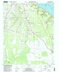
1997 Map of Hackney
USGS Topo · Published 2001About this map
Chocowinity Bay and the Pamlico River define the northeastern reaches of this landscape, where the land gives way to an intricate system of swampy runs and Pocosins. The topography is dominated by the Blount Pocosin, a low-lying wetland area drained by a series of engineered watercourses including Piney Canal, Dividing Canal, and Sheppard Run Canal. These drainage features, along with settlements like Hackney and Rover, reflect the historical efforts to manage the moist lowlands for agricultural or industrial utility. Along the high ground between these drainages, community life is marked by numerous country churches, including Haw Branch Ch and Providence Ch. This 1997 photoinspection, based on topography compiled decades earlier, reveals a rural network of branches and creeks, such as Chocowinity Creek and Rice Creek, that have historically shaped the settlement patterns of this coastal plain region.
Find a feature on this map
43 named features on this map. Tap any name to fly to it.
Don’t see what you’re looking for? This feature index may not catch every label — zoom into the map to look around manually.
Map Details
Editions of this 1997 Hackney Map
This is the sole edition of this map. No revisions or reprints were ever made.
Other maps of this area

1902 · Vanceboro
USGS Topo · 1:62,500

1903 · Chocowinity
USGS Topo · 1:62,500

1904 · Vanceboro
USGS Topo · 1:62,500

1905 · Chocowinity
USGS Topo · 1:62,500

1905 · Vanceboro
USGS Topo · 1:62,500

1943 · Plymouth
USGS Topo · 1:125,000

1950 · Edward
USGS Topo · 1:24,000

1951 · Bunyan
USGS Topo · 1:24,000

1951 · Hackney
USGS Topo · 1:24,000

1951 · Washington
USGS Topo · 1:24,000