
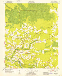
1951 Map of Bunyan
USGS Topo · Published 1952About this map
The J & W Dismal Swamp dominates the northern reaches of this coastal plain landscape, giving way to a patchwork of agricultural land and scattered rural communities in central Beaufort County. Settlement patterns follow the higher ground between the swamp and Broad Creek, with small hamlets like Bunyan and Alligoods serving as local hubs. The Norfolk Southern railway cuts through the center of the region, providing a critical link for the transport of timber and crops, while the presence of numerous rural congregations, such as Rosemary Ch and Zion Ch, underscores the community-centric nature of the area in the mid-20th century.
Find a feature on this map
28 named features on this map. Tap any name to fly to it.
Don’t see what you’re looking for? This feature index may not catch every label — zoom into the map to look around manually.
Map Details
Editions of this 1951 Bunyan Map
3 editions found
Other maps of this area

1902 · Vanceboro
USGS Topo · 1:62,500

1903 · Chocowinity
USGS Topo · 1:62,500

1904 · Vanceboro
USGS Topo · 1:62,500

1905 · Chocowinity
USGS Topo · 1:62,500

1905 · Vanceboro
USGS Topo · 1:62,500

1943 · Plymouth
USGS Topo · 1:125,000

1950 · Pinetown
USGS Topo · 1:24,000

1951 · Bath
USGS Topo · 1:24,000

1951 · Hackney
USGS Topo · 1:24,000

1951 · Washington
USGS Topo · 1:24,000