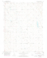
1954 Map of Haegler Ranch
USGS Topo · Published 1978About this map
Haegler Ranch and other mid-century agricultural holdings define this high-plains landscape in eastern El Paso County. The map captures an era of ranching operations reliant on a network of windmills and seasonal watercourses like Black Squirrel Creek and Brackett Creek. Settlement patterns follow the cardinal directions of the survey grid, anchored by family-named properties such as La Vega Ranch and the Hook & Line Ranch. Local transit is oriented around the Falcon Highway and Judge Orr Road, which intersect this open terrain. A lone Community Building and the VABM El Paso E Base survey marker serve as rare structural landmarks in a region dominated by drainage ditches and scattered springs. These details offer a precise view of the rural infrastructure that supported Colorado livestock ranching during the mid-20th century.
Find a feature on this map
15 named features on this map. Tap any name to fly to it.
Don’t see what you’re looking for? This feature index may not catch every label — zoom into the map to look around manually.
Map Details
Editions of this 1954 Haegler Ranch Map
3 editions found
Other maps of this area

1893 · Big Springs
USGS Topo · 1:125,000

1893 · Colorado Springs
USGS Topo · 1:125,000

1894 · Castle Rock
USGS Topo · 1:125,000

1909 · Colorado Springs
USGS Topo · 1:125,000

1913 · Castle Rock
USGS Topo · 1:125,000

1940 · Elbert
USGS Topo · 1:62,500

1942 · Colorado Springs
USGS Topo · 1:125,000

1944 · Elbert
USGS Topo · 1:62,500

1948 · Falcon
USGS Topo · 1:24,000

1948 · Falcon
USGS Topo · 1:62,500