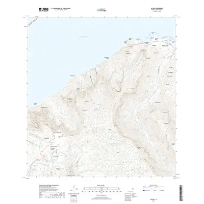
2017 Map of Haena
USGS Topo · Published 2017About this map
Hā‘ena and its neighboring coastal settlements of Halehomaha and Wainiha anchor this 2017 survey of Kaua‘i's North Shore. The topography is dominated by the massive Wainiha Valley and the steep ridges of Hono‘onāpali, where numerous vertical drops create landmarks like Hanakāpġ‘ai Falls and Limaluli Falls. Along the coast, the interplay of land and sea is marked by Makua Reef and popular littoral reaches such as Tunnels Beach and Kepuhi Beach.
Find a feature on this map
98 named features on this map. Tap any name to fly to it.
Don’t see what you’re looking for? This feature index may not catch every label — zoom into the map to look around manually.
Map Details
Editions of this 2017 Haena Map
This is the sole edition of this map. No revisions or reprints were ever made.
Other maps of this area

1954 · Kauai
USGS Topo · 1:250,000

1963 · Hanalei
USGS Topo · 1:24,000

1965 · Waimea Canyon
USGS Topo · 1:24,000

1965 · Haena
USGS Topo · 1:24,000

1965 · Makaha Point
USGS Topo · 1:24,000

1965 · Waialeale
USGS Topo · 1:24,000

1967 · Kauai
USGS Topo · 1:250,000

1970 · Kauai
USGS Topo · 1:250,000
1983 · Hanalei
USGS Topo · 1:24,000
1983 · Haena
USGS Topo · 1:24,000