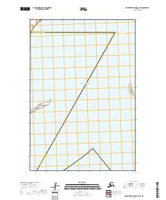
2018 Map of Hagemeister Island C-4 NW
USGS Topo · Published 2018About this map
The Pacific Ocean dominates this coastal survey, where the administrative line between the Bethel Census Area and the Dillingham Census Area shifts across open water and remote shoreline. The most prominent landform is Asigyukpak Spit, a narrow coastal feature extending into the sea. This 2018 edition provides a precise look at the shifting boundaries of the Alaska coastline, where little terrestrial infrastructure exists. Instead, the map documents the intersection of maritime geography and census divisions in a region defined by its tidal reach and the isolation of the Bering Sea coast.
Find a feature on this map
4 named features on this map. Tap any name to fly to it.
Don’t see what you’re looking for? This feature index may not catch every label — zoom into the map to look around manually.
Map Details
Editions of this 2018 Hagemeister Island C-4 NW Map
This is the sole edition of this map. No revisions or reprints were ever made.
Other maps of this area

1948 · Hagemeister Island C-4
USGS Topo · 1:63,360

1948 · Hagemeister Island C-5
USGS Topo · 1:63,360

1950 · Hagemeister Island D-5
USGS Topo · 1:63,360

1951 · Hagemeister Island
USGS Topo · 1:250,000
1952 · Hagemeister Island C-5
USGS Topo · 1:63,360

1952 · Hagemeister Island C-4
USGS Topo · 1:63,360

1954 · Hagemeister Island D-5
USGS Topo · 1:63,360

1954 · Hagemeister Island D-4
USGS Topo · 1:63,360

1957 · Hagemeister Island
USGS Topo · 1:250,000
2018 · Hagemeister Island C-4 SE
USGS Topo · 1:25,000