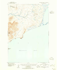
1952 Map of Hagemeister Island C-5
USGS Topo · Published 1955About this map
Slug Mountain dominates the western topography of this coastal survey, where the terrestrial landscape meets the northern reaches of Bristol Bay. The terrain transitions from these high elevations down toward the Slug River, which meanders across the tundra before reaching the sea. Along the coastline, distinctive geographical features such as Pyrite Pt and the narrow Asigyukpak Spit define the interface between land and water, near the sheltered waters of Norseman Lake.
Find a feature on this map
11 named features on this map. Tap any name to fly to it.
Don’t see what you’re looking for? This feature index may not catch every label — zoom into the map to look around manually.
Map Details
Editions of this 1952 Hagemeister Island C-5 Map
2 editions found
Other maps of this area

1948 · Hagemeister Island C-6
USGS Topo · 1:63,360

1948 · Hagemeister Island C-4
USGS Topo · 1:63,360

1948 · Hagemeister Island C-5
USGS Topo · 1:63,360

1950 · Hagemeister Island D-6
USGS Topo · 1:63,360

1950 · Hagemeister Island D-5
USGS Topo · 1:63,360

1951 · Hagemeister Island
USGS Topo · 1:250,000

1952 · Hagemeister Island C-6
USGS Topo · 1:63,360

1952 · Hagemeister Island C-4
USGS Topo · 1:63,360

1954 · Hagemeister Island D-5
USGS Topo · 1:63,360

1954 · Hagemeister Island D-4
USGS Topo · 1:63,360