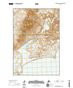
2018 Map of Hagemeister Island D-4 SW
USGS Topo · Published 2018About this map
The Oswiak River winds south through a complex network of wetlands and coastal lowlands before reaching its mouth at the Pacific Ocean. This 2018 survey illustrates the remote transition from the elevations of Virgo Mtn to the shoreline at Estus Point. The map serves as a detailed record of the administrative boundary between the Bethel Census Area and the Dillingham Census Area, which bisects the landscape horizontally. This sparsely populated coastal region is defined by its drainage patterns and the absence of established roads or settlements, highlighting the wilderness character of the terrain as it appeared in the early 21st century.
Find a feature on this map
9 named features on this map. Tap any name to fly to it.
Don’t see what you’re looking for? This feature index may not catch every label — zoom into the map to look around manually.
Map Details
Editions of this 2018 Hagemeister Island D-4 SW Map
This is the sole edition of this map. No revisions or reprints were ever made.
Other maps of this area

1948 · Hagemeister Island C-4
USGS Topo · 1:63,360

1948 · Hagemeister Island C-5
USGS Topo · 1:63,360

1950 · Hagemeister Island D-5
USGS Topo · 1:63,360

1951 · Hagemeister Island
USGS Topo · 1:250,000
1952 · Hagemeister Island C-5
USGS Topo · 1:63,360

1952 · Hagemeister Island C-4
USGS Topo · 1:63,360

1954 · Hagemeister Island D-5
USGS Topo · 1:63,360

1954 · Hagemeister Island D-4
USGS Topo · 1:63,360

1957 · Hagemeister Island
USGS Topo · 1:250,000
2018 · Hagemeister Island C-4 NW
USGS Topo · 1:25,000