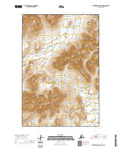
2018 Map of Hagemeister Island D-5 NE
USGS Topo · Published 2018About this map
The Kinegnak River meanders through a landscape defined by dramatic elevation changes and low-lying wetlands in this 2018 survey of the Hagemeister Island D-5 NE quadrangle. This remote Alaskan terrain is characterized by the convergence of major waterways, where the Unaluk River flows across a drainage basin marked by Township and Range boundaries including t14s r73w and t15s r73w. The map provides a detailed view of the topographical relief between these river systems, illustrating the complex hydrography of the Bethel Census Area before these waters reach the coastal reaches of the Bering Sea region. The absence of roads or permanent structures emphasizes the wilderness character of the territory, serving as a primary record of the natural corridor established by these two prominent rivers.
Find a feature on this map
6 named features on this map. Tap any name to fly to it.
Don’t see what you’re looking for? This feature index may not catch every label — zoom into the map to look around manually.
Map Details
Editions of this 2018 Hagemeister Island D-5 NE Map
This is the sole edition of this map. No revisions or reprints were ever made.
Other maps of this area

1950 · Hagemeister Island D-5
USGS Topo · 1:63,360

1951 · Goodnews
USGS Topo · 1:250,000

1951 · Hagemeister Island
USGS Topo · 1:250,000

1954 · Goodnews A-7
USGS Topo · 1:63,360

1954 · Hagemeister Island D-5
USGS Topo · 1:63,360

1954 · Hagemeister Island D-4
USGS Topo · 1:63,360

1957 · Hagemeister Island
USGS Topo · 1:250,000

1979 · Goodnews Bay
USGS Topo · 1:250,000
2017 · Goodnews Bay A-7 SW
USGS Topo · 1:25,000
2017 · Goodnews Bay A-7 SE
USGS Topo · 1:25,000