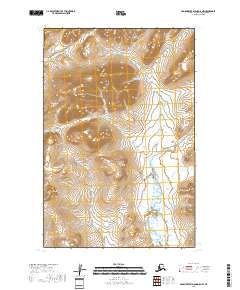
2018 Map of Hagemeister Island D-5 NW
USGS Topo · Published 2018About this map
Platinum marks a pocket of development at the foothills of Susie Mtn, where the highland terrain transitions into a wide expanse of wetlands and river drainage. This area in the Bethel Census Area is defined by its complex hydrological network, with numerous waterways including the Smalls River, Wind Cr, and Medicine Cr carving through the landscape. Further south, Kemuk Mtn stands as a prominent topographical landmark above the surrounding flats. The mapping of this territory reveals a pattern of drainage where several creeks, such as Shaw Cr and Fog Cr, feed into larger systems like the Kinegnak River and Kooklaklak River. The transition from steep peaks to low-lying marshes illustrates the varied environment of the Goodnews Bay region during the early twenty-first century.
Find a feature on this map
15 named features on this map. Tap any name to fly to it.
Don’t see what you’re looking for? This feature index may not catch every label — zoom into the map to look around manually.
Map Details
Editions of this 2018 Hagemeister Island D-5 NW Map
This is the sole edition of this map. No revisions or reprints were ever made.
Other maps of this area

1950 · Hagemeister Island D-6
USGS Topo · 1:63,360

1950 · Hagemeister Island D-5
USGS Topo · 1:63,360

1951 · Goodnews
USGS Topo · 1:250,000

1951 · Hagemeister Island
USGS Topo · 1:250,000

1954 · Goodnews A-8
USGS Topo · 1:63,360

1954 · Goodnews A-7
USGS Topo · 1:63,360

1954 · Hagemeister Island D-5
USGS Topo · 1:63,360

1957 · Hagemeister Island
USGS Topo · 1:250,000

1979 · Goodnews Bay
USGS Topo · 1:250,000
2017 · Goodnews Bay A-7 SW
USGS Topo · 1:25,000