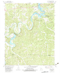
1982 Map of Hahatonka
USGS Topo · Published 1983About this map
Ha Ha Tonka State Park anchors the northeastern quadrant of this Missouri survey, featuring geological landmarks such as the Natural Bridge, Trout Glen Pool, and the subterranean depths of Island Cave Spring. The landscape is dominated by the winding path of the Niangua River, which feeds into the Niangua Arm of the Lake of the Ozarks. Near the center of the sheet, the river is harnessed by the Tunnel Dam, supported by a Powerplant, Penstock, and Substation that speak to the region's mid-century electrification efforts.
Find a feature on this map
63 named features on this map. Tap any name to fly to it.
Don’t see what you’re looking for? This feature index may not catch every label — zoom into the map to look around manually.
Map Details
Editions of this 1982 Hahatonka Map
2 editions found
Other maps of this area

1888 · Versailles
USGS Topo · 1:125,000

1893 · Versailles
USGS Topo · 1:125,000

1932 · Versailles No 4
USGS Topo · 1:48,000

1933 · Stoutland
USGS Topo · 1:62,500

1934 · Macks Creek
USGS Topo · 1:48,000

1934 · Camdenton
USGS Topo · 1:24,000

1934 · Green Bay Terrace
USGS Topo · 1:24,000

1935 · Barnumton
USGS Topo · 1:24,000

1938 · Stoutland
USGS Topo · 1:62,500

1939 · Macks Creek
USGS Topo · 1:62,500