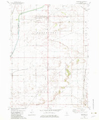
1982 Map of Hahnaman
USGS Topo · Published 1982About this map
Agricultural lands of Whiteside County are defined by a complex network of man-made drainage, vital for the productivity of the Montmorency and Hahnaman townships. The Hennepin Canal Feeder and the associated Hennepin Canal Parkway State Park represent the intersection of early industrial transport and modern conservation. This landscape is partitioned by numerous ditches, including the Winnebago Ditch and South Fork Ditch, which work in tandem with natural water bodies like Coon Creek.
Find a feature on this map
40 named features on this map. Tap any name to fly to it.
Don’t see what you’re looking for? This feature index may not catch every label — zoom into the map to look around manually.
Map Details
Editions of this 1982 Hahnaman Map
This is the sole edition of this map. No revisions or reprints were ever made.
Other maps of this area

1930 · Woodsung
USGS Topo · 1:48,000

1932 · Prophetstown
USGS Topo · 1:48,000

1934 · Morrison
USGS Topo · 1:48,000

1936 · Prophetstown
USGS Topo · 1:62,500

1940 · Morrison
USGS Topo · 1:62,500

1946 · Sterling
USGS Topo · 1:62,500

1948 · Sterling
USGS Topo · 1:62,500

1949 · Walnut
USGS Topo · 1:62,500

1958 · Aurora
USGS Topo · 1:250,000

1961 · Aurora
USGS Topo · 1:250,000