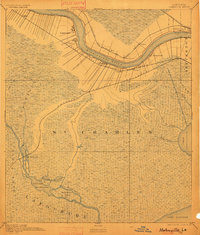
1891 Map of Hahnville
USGS Topo · Published 1901About this map
Ribbon plantations and emerging rail settlements line the banks of the Mississippi River in this 1890 survey of the Louisiana river parishes. The settlement pattern follows the high ground of the natural levees, where family-named landings and small towns like Hahnville, St Charles, and Pecan Grove cluster along the arc of the river. The map captures a pivotal moment for transportation as four major railroads—including the Texas and Pacific Railroad and the Southern Pacific Railroad—strike through the lowlands, creating new junctions at Boutte and Luling. South of the river, the landscape transitions into the vast marshes and cypress swamps of the Grand Prairie Des Allemands. This watery network includes features like Black Prince Island and Malign Bay, leading down to the expansive waters of Lake Salvador. The detailed mapping by A.E. Wilson and H.L. Baldwin Jr. provides a clear view of the complex hydrology before modern flood control reshaped the basin.
Find a feature on this map
33 named features on this map. Tap any name to fly to it.
Don’t see what you’re looking for? This feature index may not catch every label — zoom into the map to look around manually.
Map Details
Editions of this 1891 Hahnville Map
5 editions found
Other maps of this area

1891 · Hahnville
USGS Topo · 1:62,500

1891 · Spanish Fort
USGS Topo · 1:62,500

1891 · New Orleans
USGS Topo · 1:62,500

1892 · Barataria
USGS Topo · 1:62,500

1892 · Lac Des Allemands
USGS Topo · 1:62,500

1892 · Mount Airy
USGS Topo · 1:62,500

1892 · Bonnet Carre
USGS Topo · 1:62,500

1892 · Cut-Off
USGS Topo · 1:62,500

1892 · Houma
USGS Topo · 1:62,500

1932 · New Orleans NW
USGS Topo · 1:31,680