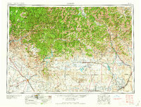
1959 Map of Hailey
USGS Topo · Published 1959About this map
The Sawtooth Mountains dominate this mid-century landscape, framing a region defined by high-altitude recreation and deep-rock mining history. While Sun Valley and Ketchum appear as established hubs, the surrounding slopes are marked by active and legacy operations like the Triumph Mine, Silver Star Queens Mine, and Silver King Mine. This era shows a transition in land use, where the resource extraction of the Boise and Sawtooth National Forests exists alongside growing water infrastructure, evidenced by the Anderson Ranch Reservoir and Magic Reservoir.
Find a feature on this map
133 named features on this map. Tap any name to fly to it.
Don’t see what you’re looking for? This feature index may not catch every label — zoom into the map to look around manually.
Map Details
Editions of this 1959 Hailey Map
2 editions found

Other maps of this area

1891 · Bear Valley
USGS Topo · 1:125,000

1892 · Mountain Home
USGS Topo · 1:125,000

1892 · Boise
USGS Topo · 1:125,000

1892 · Bisuka
USGS Topo · 1:125,000

1892 · Camas Prairie
USGS Topo · 1:125,000

1893 · Mountain Home
USGS Topo · 1:125,000

1893 · Bear Valley
USGS Topo · 1:125,000

1893 · Camas Prairie
USGS Topo · 1:125,000

1894 · Bisuka
USGS Topo · 1:125,000

1894 · Squaw Creek
USGS Topo · 1:125,000