
1959 Map of Hailey
USGS Topo · Published 1959About this map
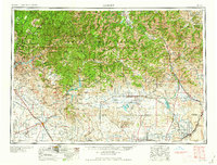
The Sawtooth Mountains and Pioneer Mountains dominate the northern skyline of this mid-century survey, a landscape defined by high-altitude mining operations and the developing recreation economy around Sun Valley. To the east near Hailey and Ketchum, several specific industrial sites are noted, including the Silver Star Queens Mine, Triumph Mine, and North Star Mine. The terrain transitions sharply from these jagged peaks to the high desert plains and irrigation-fed agricultural lands of the south, where the Union Pacific railroad corridor connects settlements like Glenns Ferry and Mountain Home. This era represents a significant period of water management in the region, evidenced by the large-scale footprints of the Anderson Ranch Reservoir, Magic Reservoir, and Mormon Reservoir. The map also captures the strategic military presence at Mountain Home Air Force Base, positioned on the flatlands south of the Danskin Mountains.
Find a feature on this map
98 named features on this map. Tap any name to fly to it.
Don’t see what you’re looking for? This feature index may not catch every label — zoom into the map to look around manually.
Map Details
Editions of this 1959 Hailey Map
2 editions found
Other maps of this area

1891 · Bear Valley
USGS Topo · 1:125,000

1892 · Mountain Home
USGS Topo · 1:125,000

1892 · Boise
USGS Topo · 1:125,000

1892 · Bisuka
USGS Topo · 1:125,000

1892 · Camas Prairie
USGS Topo · 1:125,000

1893 · Mountain Home
USGS Topo · 1:125,000

1893 · Bear Valley
USGS Topo · 1:125,000

1893 · Camas Prairie
USGS Topo · 1:125,000

1894 · Bisuka
USGS Topo · 1:125,000

1894 · Squaw Creek
USGS Topo · 1:125,000