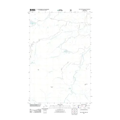
2011 Map of Half Dome Crag
USGS Topo · Published 2011About this map
Kiyo Crag and Half Dome Crag define the high-elevation landscape of this Glacier County quadrangle, where a complex network of glacial meltwater streams feeds the surrounding plains. The drainage system is particularly intricate, featuring the North Fork Little Badger Creek, South Fork Little Badger Creek, and the uniquely named Killem Quick Creek. Small alpine bodies of water such as Minnie White Horse Lake, Slippery Hoof Lake, and Dog Gun Lake are scattered throughout the territory.
Find a feature on this map
24 named features on this map. Tap any name to fly to it.
Don’t see what you’re looking for? This feature index may not catch every label — zoom into the map to look around manually.
Map Details
Editions of this 2011 Half Dome Crag Map
This is the sole edition of this map. No revisions or reprints were ever made.
Other maps of this area

1913 · Marias Pass
USGS Topo · 1:125,000

1914 · Heart Butte
USGS Topo · 1:125,000

1918 · Heart Butte
USGS Topo · 1:125,000

1958 · Crescent Cliff
USGS Topo · 1:24,000

1960 · Cut Bank
USGS Topo · 1:250,000

1963 · Cut Bank
USGS Topo · 1:250,000

1964 · Cut Bank
USGS Topo · 1:250,000

1968 · Half Dome Crag
USGS Topo · 1:24,000

1968 · Swift Reservoir
USGS Topo · 1:24,000
1968 · Morningstar Mountain
USGS Topo · 1:24,000