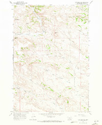
1967 Map of Half Moon Hill
USGS Topo · Published 1971About this map
Monument Hill (Rosebud Battlefield) anchors the northwestern corner of this landscape, marking a site of significant historical conflict in Big Horn County. The terrain is defined by deeply eroded drainages and high points like Eagle Nest Peak and Half Moon Hill, where the land drops away into the valley of Rosebud Creek. The presence of a Buffalo Jump near the battlefield highlights the long-standing indigenous relationship with these high-plateau rimrocks and natural traps.
Find a feature on this map
16 named features on this map. Tap any name to fly to it.
Don’t see what you’re looking for? This feature index may not catch every label — zoom into the map to look around manually.
Map Details
Editions of this 1967 Half Moon Hill Map
2 editions found
Other maps of this area

1894 · Rosebud
USGS Topo · 1:125,000

1901 · Rosebud
USGS Topo · 1:125,000

1954 · Hardin
USGS Topo · 1:250,000

1957 · Hardin
USGS Topo · 1:250,000

1958 · Hardin
USGS Topo · 1:250,000

1967 · Tongue River Dam
USGS Topo · 1:24,000

1967 · Kirby
USGS Topo · 1:24,000

1967 · Bar V Ranch NE
USGS Topo · 1:24,000
1967 · Bar V Ranch
USGS Topo · 1:24,000
1967 · Pearl School
USGS Topo · 1:24,000