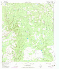
1962 Map of Hallettsville SE
USGS Topo · Published 1983About this map
The confluence of varied waterways in Lavaca County defines this rural landscape, dominated by the Lavaca River and Navidad River systems. Local life in the early 1960s was centered around small landmarks such as Solmsville Ch and various family-named water bodies. The terrain is marked by a intricate network of drainage, including Sandies Creek, Hardys Sandy Creek, and the distinct East Sandy Creek and West Sandy Creek forks. While largely agricultural and undeveloped, evidence of resource extraction appears at the Gravel Pit near the northern boundary. Modern infrastructure is represented by a large Pipeline cutting across the southern terrain, signaling the mid-century industrial shift in this part of Texas. Genealogists and local historians will find value in the specific naming of minor tributaries like Bachelor Branch, Double Branch, and Oak Branch, which often align with historical property boundaries and early settlements.
Find a feature on this map
15 named features on this map. Tap any name to fly to it.
Don’t see what you’re looking for? This feature index may not catch every label — zoom into the map to look around manually.
Map Details
Editions of this 1962 Hallettsville SE Map
2 editions found
Other maps of this area

1953 · Seguin
USGS Topo · 1:250,000

1958 · Seguin
USGS Topo · 1:250,000

1962 · Sublime
USGS Topo · 1:24,000

1962 · Hallettsville SE
USGS Topo · 1:24,000

1962 · Hallettsville
USGS Topo · 1:24,000

1964 · Cordele
USGS Topo · 1:24,000

1964 · Morales
USGS Topo · 1:24,000

1964 · Speaks
USGS Topo · 1:24,000

1964 · Ezzell
USGS Topo · 1:24,000

1965 · Hope
USGS Topo · 1:24,000