
1965 Map of Hope
USGS Topo · Published 1967About this map
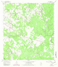
The boundary between Lavaca and DeWitt counties serves as a backdrop for this mid-1960s landscape, characterized by the winding headwaters of the Lavaca River and a dense network of creek branches. The settlement of Hope stands near the northwestern corner, situated along Scarboroughs Branch and Supplejack Creek. The area’s economic activity is evidenced by scattered Oil Well locations, a Pumping Station, and multiple Gravel Pits, suggesting a rural economy reliant on mineral extraction and livestock. Local genealogy is anchored by the Harless Cemetery and an unnamed Cemetery near Boggy Creek. The map reveals a transition from wooded creek bottoms like Big Brushy Creek to more open pastures, typical of the coastal plains region before more modern infrastructure intensified. This survey provides a clear view of the family-named landmarks and watercourses that defined the community during the transition to late-twentieth-century industrial practices.
Find a feature on this map
20 named features on this map. Tap any name to fly to it.
Don’t see what you’re looking for? This feature index may not catch every label — zoom into the map to look around manually.
Map Details
Editions of this 1965 Hope Map
2 editions found
Other maps of this area

1953 · Seguin
USGS Topo · 1:250,000

1958 · Seguin
USGS Topo · 1:250,000

1962 · Terryville
USGS Topo · 1:24,000

1962 · Hallettsville SE
USGS Topo · 1:24,000

1963 · Fordtran
USGS Topo · 1:24,000

1963 · Sweet Home
USGS Topo · 1:24,000

1964 · Morales
USGS Topo · 1:24,000
1964 · Navidad
USGS Topo · 1:24,000

1964 · Ezzell
USGS Topo · 1:24,000
1966 · Peck Branch
USGS Topo · 1:24,000