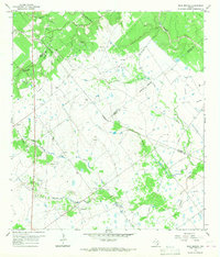
1966 Map of Peck Branch
USGS Topo · Published 1968About this map
The convergence of Victoria, DeWitt, Lavaca, and Jackson counties in the mid-1960s reveals a landscape defined by industrial extraction and scattered rural landmarks. Extensive Gravel Pits dominate the western terrain near the Victoria County line, highlighting the region's reliance on mineral resources during this era. The small settlement of Salem sits centrally, serving as a quiet focal point amidst a network of drainage systems including Haines Flat Creek and Chicolete Creek. For genealogists and local historians, the presence of the Fordtran Cem and a simple Roadside Park along the highway provides tangible links to the community's mid-century physical layout. The map also documents a heavy concentration of gas wells and pipelines, illustrating the intensification of energy infrastructure across the coastal prairie.
Find a feature on this map
18 named features on this map. Tap any name to fly to it.
Don’t see what you’re looking for? This feature index may not catch every label — zoom into the map to look around manually.
Map Details
Editions of this 1966 Peck Branch Map
2 editions found
Other maps of this area

1951 · Inez NW
USGS Topo · 1:24,000

1951 · Inez
USGS Topo · 1:24,000

1953 · Beeville
USGS Topo · 1:250,000

1953 · Seguin
USGS Topo · 1:250,000

1956 · Beeville
USGS Topo · 1:250,000

1958 · Seguin
USGS Topo · 1:250,000

1960 · Beeville
USGS Topo · 1:250,000

1962 · Terryville
USGS Topo · 1:24,000

1963 · Fordtran
USGS Topo · 1:24,000

1963 · Nursery
USGS Topo · 1:24,000