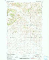
1970 Map of Halliday NE
USGS Topo · Published 1990About this map
The Fort Berthold Indian Reservation defines the northern half of this landscape, its boundary cutting across a terrain of high plateaus and creek valleys. At the northwestern edge, the rising waters of Lake Sakakawea reached an elevation of 1838 feet following the development of the Missouri River Basin project. This 1970 survey captures the transition of the land as it was impacted by large-scale water management and infrastructure, seen in the path of the Pipeline crossing the southern sections. Genealogists and local historians will find the St Johns Cem situated on the high ground between Steel Creek and Hans Creek, providing a specific point of reference for the families who settled this part of Dunn County. The map also includes fine-lined detail of selected fence and field lines, documenting the agricultural footprint in the years following the reservoir's creation.
Find a feature on this map
8 named features on this map. Tap any name to fly to it.
Don’t see what you’re looking for? This feature index may not catch every label — zoom into the map to look around manually.
Map Details
Editions of this 1970 Halliday NE Map
2 editions found
Other maps of this area

1953 · Watford City
USGS Topo · 1:250,000

1957 · Watford City
USGS Topo · 1:250,000

1967 · Watford City
USGS Topo · 1:250,000

1967 · Twin Buttes
USGS Topo · 1:24,000

1970 · Halliday NE
USGS Topo · 1:24,000

1970 · Hay Flat
USGS Topo · 1:24,000

1970 · Golden Valley NW
USGS Topo · 1:24,000

1970 · Halliday NW
USGS Topo · 1:24,000
1970 · Saddle Butte SW
USGS Topo · 1:24,000

1973 · Halliday
USGS Topo · 1:24,000