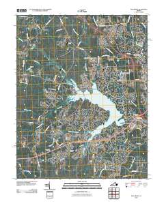
2010 Map of Hallsboro
USGS Topo · Published 2010About this map
Swift Creek Reservoir dominates the landscape south of Hallsboro, serving as the central geographic feature for the growing residential developments of Brandermill and Otterdale. This 2010 survey reflects a period of significant suburban expansion in Chesterfield County, where established family landmarks and rural cemeteries now sit adjacent to modern infrastructure. Numerous family-named burial grounds are preserved across the area, including Cheatham Cemetery, Lester Cemetery, and Fuqua Cemetery, providing critical touchpoints for local genealogists. The map also records specialized land uses of the era, such as the Southside Speedway near Falling Creek and the Woodle Airport located just off Old Hundred Rd. Along the eastern edge, the industrial and water-management history of the region is evident through features like The Midlothian Company Dam and Izaak Walton Park Dam.
Find a feature on this map
64 named features on this map. Tap any name to fly to it.
Don’t see what you’re looking for? This feature index may not catch every label — zoom into the map to look around manually.
Map Details
Editions of this 2010 Hallsboro Map
This is the sole edition of this map. No revisions or reprints were ever made.
Other maps of this area

1890 · Goochland
USGS Topo · 1:125,000

1892 · Goochland
USGS Topo · 1:125,000

1897 · Amelia
USGS Topo · 1:125,000

1936 · Richmond West
USGS Topo · 1:24,000

1942 · Westhampton
USGS Topo · 1:31,680

1943 · Fine Creek Mills
USGS Topo · 1:31,680

1943 · Chesterfield
USGS Topo · 1:31,680

1943 · Goodes Bridge
USGS Topo · 1:31,680

1943 · Hallsboro
USGS Topo · 1:31,680

1943 · Beach
USGS Topo · 1:24,000