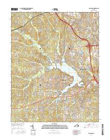
2016 Map of Hallsboro
USGS Topo · Published 2016About this map
Swift Creek Reservoir serves as the central focal point of this Chesterfield County landscape, surrounded by the suburban developments of Woodlake and Brandermill. This era of Virginia's growth is characterized by a dense network of modern residential thoroughfares, such as Woolridge Rd and Old Hundred Rd, which weave through the drainage basins of Tomahawk Cr and Otterdale Br.
Find a feature on this map
171 named features on this map. Tap any name to fly to it.
Don’t see what you’re looking for? This feature index may not catch every label — zoom into the map to look around manually.
Map Details
Editions of this 2016 Hallsboro Map
This is the sole edition of this map. No revisions or reprints were ever made.
Other maps of this area

1890 · Goochland
USGS Topo · 1:125,000

1892 · Goochland
USGS Topo · 1:125,000

1897 · Amelia
USGS Topo · 1:125,000

1936 · Richmond West
USGS Topo · 1:24,000

1942 · Westhampton
USGS Topo · 1:31,680

1943 · Fine Creek Mills
USGS Topo · 1:31,680

1943 · Chesterfield
USGS Topo · 1:31,680

1943 · Goodes Bridge
USGS Topo · 1:31,680

1943 · Hallsboro
USGS Topo · 1:31,680

1943 · Beach
USGS Topo · 1:24,000